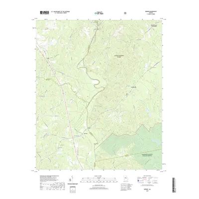
2020 Map of Berner
USGS Topo · Published 2020About this map
The Ocmulgee River carves a deep path through middle Georgia, defining the borders of Monroe, Jasper, and Butts counties. This riverine landscape is marked by unique fluvial features like Forty Acre Island, Nelson Island, and Tyler Island, while the Towaliga River joins the main branch near the settlement of Berner. The area is characterized by a network of rural roads connecting small communities such as Gladesville and Cork, with large sections of the eastern terrain protected within the Oconee National Forest and the Piedmont National Wildlife Refuge.
Find a feature on this map
70 named features on this map. Tap any name to fly to it.
Don’t see what you’re looking for? This feature index may not catch every label — zoom into the map to look around manually.
Map Details
Editions of this 2020 Berner Map
This is the sole edition of this map. No revisions or reprints were ever made.
Other maps of this area

1951 · Forsyth
USGS Topo · 1:62,500

1953 · Athens
USGS Topo · 1:250,000

1958 · Athens
USGS Topo · 1:250,000

1959 · Athens
USGS Topo · 1:250,000

1963 · Athens
USGS Topo · 1:250,000

1964 · Lloyd Shoals Dam
USGS Topo · 1:24,000
1964 · Jackson
USGS Topo · 1:24,000
1964 · Dames Ferry
USGS Topo · 1:24,000

1964 · Hillsboro
USGS Topo · 1:24,000

1972 · Monticello
USGS Topo · 1:24,000