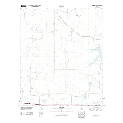
2010 Map of Bernie Lake
USGS Topo · Published 2010About this map
Pueblo sits at the northern edge of this West Texas landscape, where the topography is defined by a dense network of intermittent creeks and small reservoirs. The map reveals an area where water management is central to the land's utility, evidenced by a series of structures including the Retention Dam on Battle Creek, the Cooper Lake Dam, and the Kendall Lake Dam. These impoundments, along with Bernie Lake and Kendall Lake, reflect the complex hydraulic engineering required for this ranching and municipal environment.
Find a feature on this map
35 named features on this map. Tap any name to fly to it.
Don’t see what you’re looking for? This feature index may not catch every label — zoom into the map to look around manually.
Map Details
Editions of this 2010 Bernie Lake Map
This is the sole edition of this map. No revisions or reprints were ever made.
Other maps of this area

1890 · Breckenridge
USGS Topo · 1:125,000

1892 · Albany
USGS Topo · 1:125,000

1893 · Albany
USGS Topo · 1:125,000

1894 · Eastland
USGS Topo · 1:125,000

1931 · Baird
USGS Topo · 1:125,000

1932 · Baird
USGS Topo · 1:125,000

1954 · Abilene
USGS Topo · 1:250,000

1958 · Abilene
USGS Topo · 1:250,000

1965 · Indian Knoll
USGS Topo · 1:24,000
1965 · Moran
USGS Topo · 1:24,000