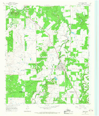
1965 Map of Moran
USGS Topo · Published 1968About this map
Moran serves as the focal point of this mid-century West Texas survey, where the Missouri Kansas Texas railroad cuts a diagonal path through the landscape. The region's industrial character is defined by a sprawling Oil Field and numerous oil wells that pepper the terrain alongside a network of pipelines. While the town of Moran is the primary population center, the map also captures the smaller settlement of Sedwick to the northwest. Local family and community history is anchored by several burial sites, including Moran Cem, Johnson Cem, Greer Cem, and Dennis Cem. The topography is marked by distinct rises such as the Greer Mountains and Round Top Mountain, while water sources like Moran Lake and Deep Creek provide relief to the dry, productive uplands. This map illustrates the intersection of traditional cattle-country geography with the intensive energy infrastructure of the 1960s.
Find a feature on this map
25 named features on this map. Tap any name to fly to it.
Don’t see what you’re looking for? This feature index may not catch every label — zoom into the map to look around manually.
Map Details
Editions of this 1965 Moran Map
This is the sole edition of this map. No revisions or reprints were ever made.
Other maps of this area

1892 · Albany
USGS Topo · 1:125,000

1893 · Albany
USGS Topo · 1:125,000

1931 · Baird
USGS Topo · 1:125,000

1932 · Baird
USGS Topo · 1:125,000

1954 · Abilene
USGS Topo · 1:250,000

1958 · Abilene
USGS Topo · 1:250,000

1961 · Eolian
USGS Topo · 1:24,000

1965 · Albany
USGS Topo · 1:24,000

1965 · McCatherine Mountain
USGS Topo · 1:24,000
1965 · Snyder Lake
USGS Topo · 1:24,000