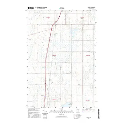
2016 Map of Beroun
USGS Topo · Published 2016About this map
Beroun sits at the heart of this Pine County landscape, where the transport corridor of Freeway Blvd cuts through a region defined by extensive wetlands and meandering waterways. The drainage patterns of Mission Creek and E Pokegama Cr dominate the terrain, feeding into larger bodies like Cross Lake and the Lawrence Mans Reservoir. This 2016 survey illustrates the persistent rural character of the area, punctuated by small community landmarks and access points like Zenith Landing and Norway Point.
Find a feature on this map
46 named features on this map. Tap any name to fly to it.
Don’t see what you’re looking for? This feature index may not catch every label — zoom into the map to look around manually.
Map Details
Editions of this 2016 Beroun Map
This is the sole edition of this map. No revisions or reprints were ever made.
Other maps of this area

1953 · Duluth
USGS Topo · 1:250,000

1953 · Stillwater
USGS Topo · 1:250,000

1955 · Stillwater
USGS Topo · 1:250,000

1958 · Stillwater
USGS Topo · 1:250,000

1958 · Duluth
USGS Topo · 1:250,000

1961 · Sandstone
USGS Topo · 1:62,500

1961 · Brook Park
USGS Topo · 1:62,500

1961 · Pine City
USGS Topo · 1:62,500

1965 · Stillwater
USGS Topo · 1:250,000
1968 · Kroschel
USGS Topo · 1:24,000