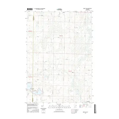
2016 Map of Berry Lake
USGS Topo · Published 2016About this map
The Oconto River winds through the eastern reaches of this landscape, anchoring a rural Wisconsin region defined by small settlements and glacial water bodies. The community of Underhill sits at the southern edge, while the crossroads of Hintz and Hayes mark the central and northern interior. Much of the western terrain is shaped by the transition across the Menominee Co and Oconto Co boundary, featuring a cluster of lakes including Berry Lake, Moshawquit Lake, and Legend Lake. Local history is rooted in the early homesteads and religious centers that established the area, represented here by the Saint Michaels Cem and Pleasant Hill Cem. The map reveals a highly structured grid of section roads like Settlement Rd and School Rd, reflecting a landscape built upon agriculture and timber as these routes navigate the wetlands surrounding Linzy Cr and Schutt Lake.
Find a feature on this map
70 named features on this map. Tap any name to fly to it.
Don’t see what you’re looking for? This feature index may not catch every label — zoom into the map to look around manually.
Map Details
Editions of this 2016 Berry Lake Map
This is the sole edition of this map. No revisions or reprints were ever made.
Other maps of this area

1942 · Breed
USGS Topo · 1:48,000

1952 · Langlade
USGS Topo · 1:48,000

1952 · Mountain
USGS Topo · 1:48,000

1954 · Shawano
USGS Topo · 1:48,000

1954 · Iron Mountain
USGS Topo · 1:250,000

1955 · Green Bay
USGS Topo · 1:250,000

1956 · Gillett
USGS Topo · 1:62,500

1959 · Iron Mountain
USGS Topo · 1:250,000

1964 · Shawano
USGS Topo · 1:62,500
1973 · Hickory Corners
USGS Topo · 1:24,000