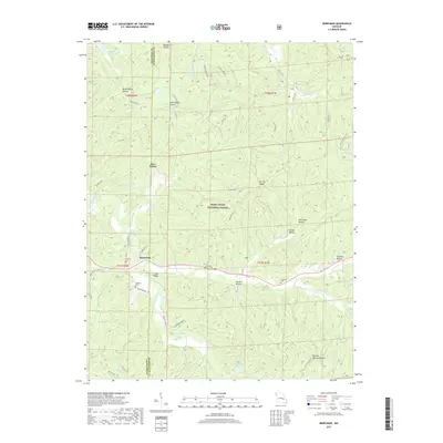
2017 Map of Berryman
USGS Topo · Published 2017About this map
The town of Berryman and the settlement of Four Points serve as anchors in this heavily wooded landscape, which straddles the boundary between Crawford Co and Washington Co. Dominated by the protected acreage of the Mark Twain National Forest, the terrain is defined by a dense network of hollows, including Henpeck Hollow, Smith Mill Hollow, and Bolling Springs Hollow. This area is shaped by the winding course of Courtois Creek and its many tributaries like Little Brazil Creek and Clear Creek. Local history is preserved in several rural burial grounds such as Whitby-Ellis Cemetery and Cresswell Cemetery, which sit alongside historic transit corridors like Floyd Tower Road. The presence of Woods Lake and Timberlane Lake provides a contrast to the high ridges of Shirley Ridge and Cedar Ridge, illustrating the varied topography of this Ozark upland region.
Find a feature on this map
57 named features on this map. Tap any name to fly to it.
Don’t see what you’re looking for? This feature index may not catch every label — zoom into the map to look around manually.
Map Details
Editions of this 2017 Berryman Map
This is the sole edition of this map. No revisions or reprints were ever made.
Other maps of this area

1901 · De Soto
USGS Topo · 1:125,000

1903 · Sullivan
USGS Topo · 1:125,000

1906 · Potosi
USGS Topo · 1:62,500

1943 · Berryman
USGS Topo · 1:62,500

1945 · Berryman
USGS Topo · 1:62,500

1946 · Richwoods
USGS Topo · 1:62,500

1947 · Sullivan
USGS Topo · 1:62,500

1948 · Richwoods
USGS Topo · 1:62,500

1949 · Saint Louis
USGS Topo · 1:250,000

1949 · Sullivan
USGS Topo · 1:62,500