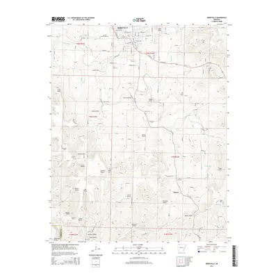
2014 Map of Berryville
USGS Topo · Published 2014About this map
Berryville serves as the focal point of this Ozark plateau landscape, where the street grid of E Church Ave and S Main St meets the rural reaches of Carroll County. The topography is defined by a series of steep hollows and named high points like Pension Mtn and Indigo Knob. A legacy of pioneer-era water crossings is evident in the multiple fords identified along the creeks, including McKennon Ford and Simmons Ford. These historical transit points, along with scattered family cemeteries like Briley Cem and Rush Cem, reflect the early settlement patterns of a region deeply connected to its river valleys and springs. To the south, the terrain becomes increasingly complex around Cabanal, marked by numerous drainage features such as Waterfall Hollow and Lead Hollow that feed into the larger watershed of Osage Creek.
Find a feature on this map
65 named features on this map. Tap any name to fly to it.
Don’t see what you’re looking for? This feature index may not catch every label — zoom into the map to look around manually.
Map Details
Editions of this 2014 Berryville Map
This is the sole edition of this map. No revisions or reprints were ever made.
Other maps of this area

1900 · Eureka Springs
USGS Topo · 1:125,000

1901 · Eureka Springs
USGS Topo · 1:125,000

1904 · Harrison
USGS Topo · 1:125,000

1905 · Harrison
USGS Topo · 1:125,000

1945 · Harrison
USGS Topo · 1:250,000

1949 · Harrison
USGS Topo · 1:250,000

1954 · Harrison
USGS Topo · 1:250,000

1958 · Harrison
USGS Topo · 1:250,000

1964 · Harrison
USGS Topo · 1:250,000
1968 · Osage
USGS Topo · 1:24,000