1968 Map of Osage
USGS Topo · Published 1969About this map
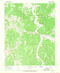
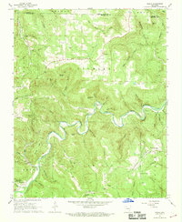
Osage Creek carves a deep valley through this Carroll County landscape, serving as the central artery for the small settlements of Osage and Conner. The map reveals a post-war rural infrastructure defined by scattered family-named cemeteries and remote hollows, such as Saffer Hollow and Lady Hollow. These deep-cut drainages emphasize the topographic isolation of high points like Usrey Mountain and Black Mountain.
Find a feature on this map
39 named features on this map. Tap any name to fly to it.
Don’t see what you’re looking for? This feature index may not catch every label — zoom into the map to look around manually.
Map Details
Editions of this 1968 Osage Map
2 editions found

Other maps of this area

1900 · Eureka Springs
USGS Topo · 1:125,000

1901 · Eureka Springs
USGS Topo · 1:125,000

1904 · Harrison
USGS Topo · 1:125,000

1905 · Harrison
USGS Topo · 1:125,000

1945 · Harrison
USGS Topo · 1:250,000

1949 · Harrison
USGS Topo · 1:250,000

1954 · Harrison
USGS Topo · 1:250,000

1958 · Harrison
USGS Topo · 1:250,000

1964 · Harrison
USGS Topo · 1:250,000
1967 · Ponca
USGS Topo · 1:24,000