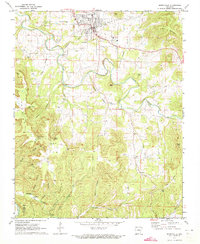
1972 Map of Berryville
USGS Topo · Published 1973About this map
Berryville serves as the primary hub in this early 1970s survey, surrounded by a complex network of Ozark hollows and ridges. The landscape is defined by the winding course of Osage Creek and its many tributaries, including Mill Branch and Warden Branch. Cultural landmarks are scattered throughout the hills, from the Fairground and Waterworks north of the city to the Grange Hall near Harris Point.
Find a feature on this map
50 named features on this map. Tap any name to fly to it.
Don’t see what you’re looking for? This feature index may not catch every label — zoom into the map to look around manually.
Map Details
Editions of this 1972 Berryville Map
This is the sole edition of this map. No revisions or reprints were ever made.
Other maps of this area

1900 · Eureka Springs
USGS Topo · 1:125,000

1901 · Eureka Springs
USGS Topo · 1:125,000

1904 · Harrison
USGS Topo · 1:125,000

1905 · Harrison
USGS Topo · 1:125,000

1945 · Harrison
USGS Topo · 1:250,000

1949 · Harrison
USGS Topo · 1:250,000

1954 · Harrison
USGS Topo · 1:250,000

1958 · Harrison
USGS Topo · 1:250,000

1964 · Harrison
USGS Topo · 1:250,000
1968 · Osage
USGS Topo · 1:24,000