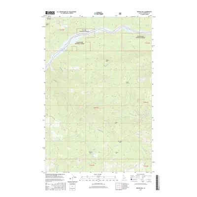
2017 Map of Bertha Hill
USGS Topo · Published 2017About this map
Bertha Hill rises as a prominent landmark in this high-elevation landscape of the Bitterroot Mountains, where the boundaries of the Clearwater National Forest and St. Joe National Forest converge. The terrain is defined by a series of high ridges and connective passes, including Lovell Saddle, Black Bear Saddle, and Township Saddle, which dictate the primitive road network. Significant infrastructure like Benton Butte Rd and Telephone Creek Rd provides access through these heavily timbered slopes. The northern edge of the map shows the impact of mid-century water management with the reaches of the Dworshak Reservoir filling the deep drainage. This 2017 survey documents the modern intersection of logging access roads, Forest Service lands, and natural spring sites such as Thunder Spring, preserving the contemporary configuration of a region long shaped by the timber industry and backcountry management.
Find a feature on this map
42 named features on this map. Tap any name to fly to it.
Don’t see what you’re looking for? This feature index may not catch every label — zoom into the map to look around manually.
Map Details
Editions of this 2017 Bertha Hill Map
This is the sole edition of this map. No revisions or reprints were ever made.
Other maps of this area

1923 · Washington Creek
USGS Topo · 1:125,000

1936 · Boehls Butte
USGS Topo · 1:48,000

1938 · Headquarters
USGS Topo · 1:48,000

1943 · Boehls Butte
USGS Topo · 1:62,500

1944 · Headquarters
USGS Topo · 1:62,500

1956 · Hamilton
USGS Topo · 1:250,000

1959 · Hamilton
USGS Topo · 1:250,000

1960 · Hamilton
USGS Topo · 1:250,000
1963 · Buzzard Roost
USGS Topo · 1:24,000

1964 · Hamilton
USGS Topo · 1:250,000