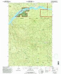
1994 Map of Bertha Hill
USGS Topo · Published 1997About this map
Dworshak Reservoir and the North Fork Clearwater River Reservoir dominate the northern landscape of this Clearwater County region. The topography is defined by high ridgelines and named peaks including Bertha Hill, Boehls Butte, and Benton Butte, which separate the various drainages of the Clearwater National Forest. The map illustrates a complex network of forest management and access, where the Floodwood State Forest meets federal lands. Strategic mountain passes and landmarks such as Lovell Saddle, Black Bear Saddle, and Cougar Rock serve as key navigational points within the densely wooded terrain. Numerous creeks, including Benton Creek and Elkberry Creek, carve deep drainages toward the reservoir system, reflecting the area's role in the regional watershed and timber economy of the late twentieth century.
Find a feature on this map
29 named features on this map. Tap any name to fly to it.
Don’t see what you’re looking for? This feature index may not catch every label — zoom into the map to look around manually.
Map Details
Editions of this 1994 Bertha Hill Map
This is the sole edition of this map. No revisions or reprints were ever made.
Other maps of this area

1923 · Washington Creek
USGS Topo · 1:125,000

1936 · Boehls Butte
USGS Topo · 1:48,000

1938 · Headquarters
USGS Topo · 1:48,000

1943 · Boehls Butte
USGS Topo · 1:62,500

1944 · Headquarters
USGS Topo · 1:62,500

1956 · Hamilton
USGS Topo · 1:250,000

1959 · Hamilton
USGS Topo · 1:250,000

1960 · Hamilton
USGS Topo · 1:250,000
1963 · Buzzard Roost
USGS Topo · 1:24,000

1964 · Hamilton
USGS Topo · 1:250,000