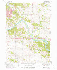
1968 Map of Bertram
USGS Topo · Published 1976About this map
The Cedar River carves a winding path through this Iowa landscape, where the expanding eastern edge of Cedar Rapids meets the rural townships of Marion and Bertram. By the late 1960s, urban growth is evidenced by a concentration of schools like Erskine Sch and All Saints Sch, while the outlying areas maintain a character defined by river-valley industry and recreation. The southeastern corner is dominated by the limestone bluffs and riverbanks of Palisades-Kepler State Park.
Find a feature on this map
34 named features on this map. Tap any name to fly to it.
Don’t see what you’re looking for? This feature index may not catch every label — zoom into the map to look around manually.
Map Details
Editions of this 1968 Bertram Map
Other maps of this area

1887 · Cedar Rapids
USGS Topo · 1:62,500

1888 · Marion
USGS Topo · 1:62,500

1889 · Marion
USGS Topo · 1:62,500

1890 · Anamosa
USGS Topo · 1:62,500

1891 · Mechanicsville
USGS Topo · 1:62,500

1891 · Cedar Rapids
USGS Topo · 1:62,500

1894 · Mechanicsville
USGS Topo · 1:62,500

1900 · Anamosa
USGS Topo · 1:125,000

1901 · Stanwood
USGS Topo · 1:125,000

1903 · Fairfax
USGS Topo · 1:125,000