
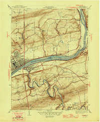
1946 Map of Berwick
USGS Topo · Published 1946About this map
The industrial and riverine character of Berwick and its sister borough Nescopeck is captured here just after World War II. The Susquehanna River serves as the central artery, punctuated by Hess I and Rocky I, while the Delaware Lackawanna and Western railroad tracks follow the northern bank through Lackawanna Bend. This era shows a dense network of rural infrastructure, where numerous small schoolhouses like Zaner Sch and Red Rock Sch served the surrounding townships of Salem and Black Creek.
Find a feature on this map
43 named features on this map. Tap any name to fly to it.
Don’t see what you’re looking for? This feature index may not catch every label — zoom into the map to look around manually.
Map Details
Editions of this 1946 Berwick Map
2 editions found
Other maps of this area

1889 · Catawissa
USGS Topo · 1:62,500

1892 · Catawissa
USGS Topo · 1:62,500

1892 · Mahanoy
USGS Topo · 1:62,500

1893 · Mahanoy
USGS Topo · 1:62,500

1894 · Catawissa
USGS Topo · 1:62,500

1894 · Shickshinny
USGS Topo · 1:62,500

1894 · Bloomsburg
USGS Topo · 1:62,500

1946 · Sybertsville
USGS Topo · 1:31,680

1946 · Nanticoke
USGS Topo · 1:31,680

1946 · Shickshinny
USGS Topo · 1:31,680