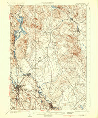
1937 Map of Berwick
USGS Topo · Published 1937About this map
The Salmon Falls River serves as the winding border between Maine and New Hampshire on this 1937 topographic study, defining the industrial and social character of the borderlands. Dense rail networks of the Boston and Maine Railroad and the Portland and Rochester Railroad converge at major hubs like Rochester and Somersworth, while specialized stops such as Hayes Sta and Rindgemere Sta highlight the era's dependence on rail for both transit and commerce. Away from the river, the landscape of York and Strafford Counties is dotted with rural landmarks including Walnut Grove Sch and the North Rochester PO. The terrain rises to notable peaks like Bauneg Beg Hill and Pine Hill, contrasting with low-lying areas such as Heath Bog and Gate Swamp, reflecting a region defined by its varied topography and early 20th-century transportation corridors.
Find a feature on this map
65 named features on this map. Tap any name to fly to it.
Don’t see what you’re looking for? This feature index may not catch every label — zoom into the map to look around manually.
Map Details
Editions of this 1937 Berwick Map
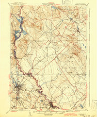
3 editions found

Other maps of this area

1891 · Berwick
USGS Topo · 1:62,500

1891 · Kennebunk
USGS Topo · 1:62,500

1891 · Buxton
USGS Topo · 1:62,500

1891 · Newfield
USGS Topo · 1:62,500

1892 · Buxton
USGS Topo · 1:62,500

1893 · Kennebunk
USGS Topo · 1:62,500

1893 · Dover
USGS Topo · 1:62,500

1893 · Berwick
USGS Topo · 1:62,500

1893 · York
USGS Topo · 1:62,500

1893 · Buxton
USGS Topo · 1:62,500