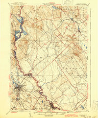
1937 Map of Berwick
USGS Topo · Published 1942About this map
The Salmon Falls River serves as the winding border between Maine and New Hampshire in this pre-war survey, anchoring a landscape of mill towns and interconnected rail lines. The industrial centers of Rochester and Somersworth are depicted in detail, showing a high density of rail infrastructure including the Boston and Maine Railroad and the Rochester and Portland line. Beyond the urban cores, the map reveals a rural geography of neighborhood-scale landmarks like the Walnut Grove Ch and S Milton Sch. To the east, the terrain rises toward Bauneg Beg and transitions into the drainage basin of the Mousam River near Sanford. This map captures the region at a time when small rail stops like Hayes Sta and Rindgemere Sta still facilitated local movement between the timbered uplands and the river-powered manufacturing hubs.
Find a feature on this map
62 named features on this map. Tap any name to fly to it.
Don’t see what you’re looking for? This feature index may not catch every label — zoom into the map to look around manually.
Map Details
Editions of this 1937 Berwick Map
3 editions found

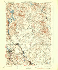
Other maps of this area

1891 · Berwick
USGS Topo · 1:62,500

1891 · Kennebunk
USGS Topo · 1:62,500

1891 · Buxton
USGS Topo · 1:62,500

1891 · Newfield
USGS Topo · 1:62,500

1892 · Buxton
USGS Topo · 1:62,500

1893 · Kennebunk
USGS Topo · 1:62,500

1893 · Dover
USGS Topo · 1:62,500

1893 · Berwick
USGS Topo · 1:62,500

1893 · York
USGS Topo · 1:62,500

1893 · Buxton
USGS Topo · 1:62,500