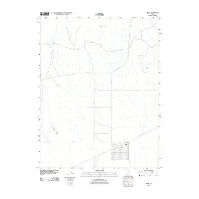
2011 Map of Beryl
USGS Topo · Published 2011About this map
Beryl centers this high-desert landscape in southwestern Utah, showcasing a grid-based settlement pattern that defines the local agrarian and residential layout. The community is situated at the intersection of several significant regional corridors, including Beryl Rd, 800th W, and the Beryl Milford Rd. This 2011 survey reveals an arid environment marked by intermittent watercourses like Negro Liza Wash and isolated water sources such as Culver Spring to the north. The topography is largely defined by the gradual ascent toward North Peaks and the distinct elevations of Websters Knolls. The road network, including long stretches of 8 Mile Rd, illustrates the vast distances between localized hubs in Iron County. This map is particularly useful for observing the precise alignment of rural properties and section lines in this portion of the Escalante Valley.
Find a feature on this map
15 named features on this map. Tap any name to fly to it.
Don’t see what you’re looking for? This feature index may not catch every label — zoom into the map to look around manually.
Map Details
Editions of this 2011 Beryl Map
This is the sole edition of this map. No revisions or reprints were ever made.
Other maps of this area

1885 · St. George
USGS Topo · 1:250,000

1891 · St. George
USGS Topo · 1:250,000

1953 · Richfield
USGS Topo · 1:250,000

1953 · Cedar City
USGS Topo · 1:250,000

1958 · Richfield
USGS Topo · 1:250,000

1958 · Cedar City
USGS Topo · 1:250,000

1962 · Cedar City
USGS Topo · 1:250,000

1971 · Bible Spring
USGS Topo · 1:24,000

1971 · Steamboat Mtn
USGS Topo · 1:24,000
1972 · Mountain Spring Peak
USGS Topo · 1:24,000