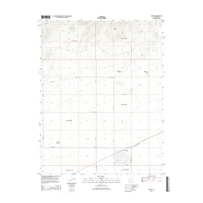
2014 Map of Beryl
USGS Topo · Published 2014About this map
The Escalante Desert dominates this 2014 survey of Iron County, Utah, where the small settlement of Beryl sits along a prominent rail corridor. The landscape is defined by the contrast between the vast arid basin and the elevated terrain of the North Peaks and Websters Knolls. Water sources, though scarce, are specifically noted at Culver Spring and the Negro Liza Wash, which likely dictated early ranching or travel patterns. The map details an extensive grid of modern roads and historical routes, including the Lehi Wood Trl and Liza E Pipe Line Rd, reflecting the area's development around transportation and utility infrastructure. Local topography is captured through Trail Draw and the distinct township and range boundaries that partitioned this corner of the Great Basin.
Find a feature on this map
27 named features on this map. Tap any name to fly to it.
Don’t see what you’re looking for? This feature index may not catch every label — zoom into the map to look around manually.
Map Details
Editions of this 2014 Beryl Map
This is the sole edition of this map. No revisions or reprints were ever made.
Other maps of this area

1885 · St. George
USGS Topo · 1:250,000

1891 · St. George
USGS Topo · 1:250,000

1953 · Richfield
USGS Topo · 1:250,000

1953 · Cedar City
USGS Topo · 1:250,000

1958 · Richfield
USGS Topo · 1:250,000

1958 · Cedar City
USGS Topo · 1:250,000

1962 · Cedar City
USGS Topo · 1:250,000

1971 · Bible Spring
USGS Topo · 1:24,000

1971 · Steamboat Mtn
USGS Topo · 1:24,000
1972 · Mountain Spring Peak
USGS Topo · 1:24,000