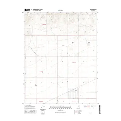
2017 Map of Beryl
USGS Topo · Published 2017About this map
The Escalante Desert dominates this corner of Iron County, where the grid-based layout of the Beryl settlement stands in contrast to the surrounding arid terrain. Located in southwestern Utah, the area is defined by its transition from the high elevations of the North Peaks in the north to the broad valley floor. Significant water features like Culver Spring and the Negro Liza Wash suggest the vital role of limited water resources in this desert landscape. The presence of Liza East-Pipe Line Rd and Eight Mile Rd indicates an infrastructure built around resource management and ranching connectivity. To the east, the distinct elevation of Websters Knolls provides a landmark against the open flats, while the townsite of Beryl shows a concentrated pattern of residential or agricultural development along the N Beryl Hwy.
Find a feature on this map
24 named features on this map. Tap any name to fly to it.
Don’t see what you’re looking for? This feature index may not catch every label — zoom into the map to look around manually.
Map Details
Editions of this 2017 Beryl Map
This is the sole edition of this map. No revisions or reprints were ever made.
Other maps of this area

1885 · St. George
USGS Topo · 1:250,000

1891 · St. George
USGS Topo · 1:250,000

1953 · Richfield
USGS Topo · 1:250,000

1953 · Cedar City
USGS Topo · 1:250,000

1958 · Richfield
USGS Topo · 1:250,000

1958 · Cedar City
USGS Topo · 1:250,000

1962 · Cedar City
USGS Topo · 1:250,000

1971 · Bible Spring
USGS Topo · 1:24,000

1971 · Steamboat Mtn
USGS Topo · 1:24,000
1972 · Mountain Spring Peak
USGS Topo · 1:24,000