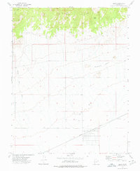
1972 Map of Beryl
USGS Topo · Published 1976About this map
The small community of Beryl serves as the central hub of this Iron County landscape, positioned along the vital Union Pacific railroad line. The map illustrates a transitional environment where the high elevations of the North Peaks in the north give way to the broad alluvial plains of the Escalante Desert. Notable water sources like Culver Spring and several wells suggest the importance of groundwater in this arid region, while the Negro Liza Wash drains the northern highlands toward the desert floor. The grid-like street pattern of the settlement at Beryl and the presence of a Gravel Pit near the tracks reflect the infrastructure of a mid-century rail-side town. Further into the interior, landforms such as Websters Knolls and various Jeep Trails indicate a landscape used for livestock grazing and local extraction.
Find a feature on this map
14 named features on this map. Tap any name to fly to it.
Don’t see what you’re looking for? This feature index may not catch every label — zoom into the map to look around manually.
Map Details
Editions of this 1972 Beryl Map
This is the sole edition of this map. No revisions or reprints were ever made.
Other maps of this area

1885 · St. George
USGS Topo · 1:250,000

1891 · St. George
USGS Topo · 1:250,000

1953 · Richfield
USGS Topo · 1:250,000

1953 · Cedar City
USGS Topo · 1:250,000

1958 · Richfield
USGS Topo · 1:250,000

1958 · Cedar City
USGS Topo · 1:250,000

1962 · Cedar City
USGS Topo · 1:250,000

1971 · Bible Spring
USGS Topo · 1:24,000

1971 · Steamboat Mtn
USGS Topo · 1:24,000
1972 · Mountain Spring Peak
USGS Topo · 1:24,000