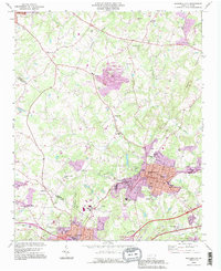
1993 Map of Bessemer City
USGS Topo · Published 1996About this map
The industrial and community development of the Gaston and Cleveland County border is recorded here in the mid-1990s. The urban core of Bessemer City is defined by its street grid, including Maine Ave and Alabama Ave, while local educational and civic life centers on Bessemer City High Sch and Lincoln Jr High Sch. The map documents a landscape transitioning from historical extraction to modern residential and utility use, evidenced by the numerous Mines and Tailings Ponds situated near the newer developments of Westview Gardens. To the west, the rural character is preserved around the base of Chestnut Ridge through a network of country churches like Chestnut Ridge Ch, Patterson Grove Ch, and Ebenezer Ch. Significant water features including Beaverdam Creek and Crowders Creek carve through the terrain, while the Southern railroad line facilitates the movement of goods through this manufacturing and textile corridor.
Find a feature on this map
65 named features on this map. Tap any name to fly to it.
Don’t see what you’re looking for? This feature index may not catch every label — zoom into the map to look around manually.
Map Details
Editions of this 1993 Bessemer City Map
2 editions found
Other maps of this area

1906 · Kings Mountain
USGS Topo · 1:62,500

1908 · Kings Mountain
USGS Topo · 1:62,500

1909 · Lincolnton
USGS Topo · 1:62,500

1911 · Lincolnton
USGS Topo · 1:62,500

1914 · Gastonia
USGS Topo · 1:48,000

1916 · Gastonia
USGS Topo · 1:62,500

1947 · Clover
USGS Topo · 1:62,500

1949 · Clover
USGS Topo · 1:62,500

1953 · Charlotte
USGS Topo · 1:250,000

1954 · Charlotte
USGS Topo · 1:250,000