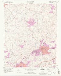
1993 Map of Bessemer City
USGS Topo · Published 1996About this map
The industrial and residential expansion of Bessemer City defines this 1993 study, showing the city's grid-patterned core reaching toward Vantine and Kings Mountain in the south. The landscape is heavily marked by the region's mining legacy, with numerous Tailings Ponds and active extraction sites dotting the area between Long Creek and Abernethy Creek. This document captures a period of transition where traditional community anchors like Chestnut Ridge Ch and Ebenezer Ch stand alongside modern developments, including the Rhynes Airfield and the sprawling infrastructure of the Filtration Plant.
Find a feature on this map
70 named features on this map. Tap any name to fly to it.
Don’t see what you’re looking for? This feature index may not catch every label — zoom into the map to look around manually.
Map Details
Editions of this 1993 Bessemer City Map
2 editions found
Other maps of this area

1906 · Kings Mountain
USGS Topo · 1:62,500

1908 · Kings Mountain
USGS Topo · 1:62,500

1909 · Lincolnton
USGS Topo · 1:62,500

1911 · Lincolnton
USGS Topo · 1:62,500

1914 · Gastonia
USGS Topo · 1:48,000

1916 · Gastonia
USGS Topo · 1:62,500

1947 · Clover
USGS Topo · 1:62,500

1949 · Clover
USGS Topo · 1:62,500

1953 · Charlotte
USGS Topo · 1:250,000

1954 · Charlotte
USGS Topo · 1:250,000