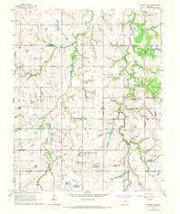
1966 Map of Bethany NE
USGS Topo · Published 1967About this map
Spring Creek and Deer Creek wind through the shifting suburban and rural landscape of central Oklahoma in the mid-1960s. This survey documents a significant period of growth where the Oklahoma City Corporate Boundary and the Edmond Corp Bdy begin to converge. Despite the expanding municipal footprints, the map preserves the location of traditional community anchors like the Deer Creek Sch, Bethel Ch, and the Higbee Community Hall. Regional infrastructure and industry are evidenced by a Gas Processing Plant and scattered Oil Wells, while local family history is anchored by the Christner Cem and Whistler Cem. The drainage patterns of West Bloody Creek and Chisholm Creek define the underlying topography that would soon be reshaped by late-twentieth-century residential development.
Find a feature on this map
34 named features on this map. Tap any name to fly to it.
Don’t see what you’re looking for? This feature index may not catch every label — zoom into the map to look around manually.
Map Details
Editions of this 1966 Bethany NE Map
Other maps of this area

1892 · Guthrie
USGS Topo · 1:62,500

1892 · Edmond
USGS Topo · 1:62,500

1892 · Kingfisher
USGS Topo · 1:125,000

1895 · Kingfisher
USGS Topo · 1:125,000

1935 · Spencer
USGS Topo · 1:24,000

1935 · Edmond
USGS Topo · 1:48,000

1940 · Edmond
USGS Topo · 1:62,500

1951 · Britton
USGS Topo · 1:24,000

1954 · Oklahoma City
USGS Topo · 1:250,000
1956 · Spencer
USGS Topo · 1:24,000