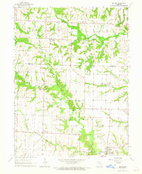
1964 Map of Bethel
USGS Topo · Published 1965About this map
The Little Fabius River and North Fabius River wind through the northern townships of this mid-1960s survey of the Shelby and Knox County line. The settlement of Bethel anchors the southern portion of the map, characterized by a concentrated grid of streets and several local landmarks including Hebron Cem, Zion Cem, and Pickett Cem. Small agricultural hamlets like Plevna and Epworth are visible, serving as focal points for the surrounding rural sections. The landscape is dotted with numerous country churches and cemeteries, such as Mount Pisgah Ch and its adjacent Mount Pisgah Park, which reflect the community centers of the era. The terrain is defined by the branching tributaries of the Fabius system, including North Tiger Fork and Garnett Branch, which create a network of drainage across the primarily agricultural plains.
Find a feature on this map
25 named features on this map. Tap any name to fly to it.
Don’t see what you’re looking for? This feature index may not catch every label — zoom into the map to look around manually.
Map Details
Editions of this 1964 Bethel Map
2 editions found
Other maps of this area

1903 · Kahoka
USGS Topo · 1:125,000

1903 · Palmyra
USGS Topo · 1:125,000

1903 · Edina
USGS Topo · 1:125,000

1948 · Quincy
USGS Topo · 1:250,000

1950 · La Belle
USGS Topo · 1:24,000

1951 · La Belle
USGS Topo · 1:24,000

1953 · Moberly
USGS Topo · 1:250,000

1954 · Centerville
USGS Topo · 1:250,000

1954 · Moberly
USGS Topo · 1:250,000

1956 · Quincy
USGS Topo · 1:250,000