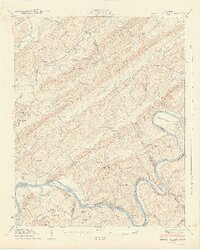
1941 Map of Bethel Valley
USGS Topo · Published 1941About this map
Clinch River topography in the early 1940s reveals a ridge-and-valley landscape defined by the winding Watts Bar Reservoir and the rural community of Wheat. This survey, conducted by the Tennessee Valley Authority and the Geological Survey, documents the area just as the reservoir was reshaping the river banks near Gallaher Bend and Jones Island. The map is particularly valuable for its detail of local infrastructure, showing the White Wing Ferry crossing and established thoroughfares like Buttermilk Road.
Find a feature on this map
69 named features on this map. Tap any name to fly to it.
Don’t see what you’re looking for? This feature index may not catch every label — zoom into the map to look around manually.
Map Details
Editions of this 1941 Bethel Valley Map
3 editions found
Other maps of this area

1893 · Briceville
USGS Topo · 1:125,000

1895 · Loudon
USGS Topo · 1:125,000

1895 · Briceville
USGS Topo · 1:125,000

1896 · Briceville
USGS Topo · 1:125,000

1935 · Lenoir City
USGS Topo · 1:24,000

1935 · Elverton
USGS Topo · 1:24,000

1935 · Bethel Valley
USGS Topo · 1:24,000

1935 · Lovell
USGS Topo · 1:24,000

1936 · Cave Creek
USGS Topo · 1:24,000

1936 · Windrock
USGS Topo · 1:24,000