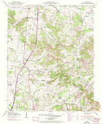
1949 Map of Bethesda
USGS Topo · Published 1969About this map
The Harpeth River and its numerous tributaries, including Goose Creek and the West Fork Harpeth River, carve a complex drainage pattern across this Williamson County landscape. Small rural communities such as Peytonsville, Bethesda, and the curiously named Pull Tight serve as local hubs, connected by the Lewisburg Franklin Pike and Arno Pike. The map reveals a dense network of family-named landmarks, such as Hardeman Cem, Gosey Cem, and Merritt Cem, reflecting generations of settlement along the fertile creek bottoms and ridges.
Find a feature on this map
90 named features on this map. Tap any name to fly to it.
Don’t see what you’re looking for? This feature index may not catch every label — zoom into the map to look around manually.
Map Details
Editions of this 1949 Bethesda Map
3 editions found
Other maps of this area

1909 · Franklin
USGS Topo · 1:62,500

1936 · Chapel Hill
USGS Topo · 1:24,000

1936 · Rally Hill
USGS Topo · 1:24,000

1936 · Spring Hill
USGS Topo · 1:24,000

1936 · Carters Creek
USGS Topo · 1:24,000

1936 · Bethesda
USGS Topo · 1:24,000

1941 · Carters Creek
USGS Topo · 1:24,000

1942 · Lebanon
USGS Topo · 1:100,000

1944 · Shelbyville
USGS Topo · 1:100,000

1946 · Leipers Fork
USGS Topo · 1:24,000