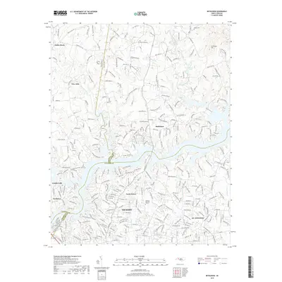
2019 Map of Bethlehem
USGS Topo · Published 2019About this map
Lake Hickory serves as the central geographic divider in this North Carolina landscape, separating the residential expansions of Hickory and St. Stephens to the south from the more dispersed rural communities to the north. This modern survey illustrates the suburban character of North Hickory, where planned streets and memory gardens like Woodlawn Memorial Gardens sit alongside the winding tributaries of Falling Creek and Snow Creek.
Find a feature on this map
296 named features on this map. Tap any name to fly to it.
Don’t see what you’re looking for? This feature index may not catch every label — zoom into the map to look around manually.
Map Details
Editions of this 2019 Bethlehem Map
This is the sole edition of this map. No revisions or reprints were ever made.
Other maps of this area

1895 · Hickory
USGS Topo · 1:125,000

1953 · Charlotte
USGS Topo · 1:250,000

1954 · Charlotte
USGS Topo · 1:250,000

1960 · Charlotte
USGS Topo · 1:250,000

1962 · Charlotte
USGS Topo · 1:250,000

1970 · Bethlehem
USGS Topo · 1:24,000

1970 · Newton
USGS Topo · 1:24,000
1970 · Granite Falls
USGS Topo · 1:24,000
1970 · Ellendale
USGS Topo · 1:24,000
1970 · Longview
USGS Topo · 1:24,000