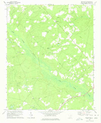
1970 Map of Bethune NW
USGS Topo · Published 1975About this map
The Little Lynches River carves a broad valley through this portion of Kershaw County, creating a landscape defined by its complex drainage network and early rural industry. Water management for local milling is evident at Stevens Millpond and Bakers Millpond, which harness the flow of Mills Creek and Shirley Creek. These water-powered sites, alongside the Seaboard Coast Line railroad in the south, illustrate the transition from traditional river-valley economies to rail-based transport in the 20th century.
Find a feature on this map
20 named features on this map. Tap any name to fly to it.
Don’t see what you’re looking for? This feature index may not catch every label — zoom into the map to look around manually.
Map Details
Editions of this 1970 Bethune NW Map
This is the sole edition of this map. No revisions or reprints were ever made.
Other maps of this area

1935 · Camden
USGS Topo · 1:48,000

1938 · Camden
USGS Topo · 1:62,500

1941 · Spartanburg
USGS Topo · 1:250,000

1942 · Camden
USGS Topo · 1:125,000

1953 · Spartanburg
USGS Topo · 1:250,000

1960 · Spartanburg
USGS Topo · 1:250,000

1963 · Spartanburg
USGS Topo · 1:250,000

1964 · Spartanburg
USGS Topo · 1:250,000

1967 · Angelus
USGS Topo · 1:24,000

1967 · Mount Pisgah
USGS Topo · 1:24,000