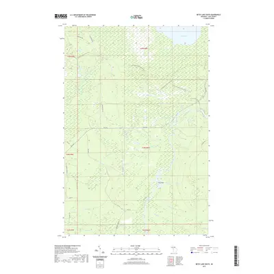
2019 Map of Betsy Lake South
USGS Topo · Published 2019About this map
The Tahquamenon River snakes through the dense wetlands and timberlands of Luce County, providing a central artery for the region's complex hydrology. This interior landscape is defined by its vast network of water bodies, from the prominent Betsy Lake in the north to the smaller Loon Lake and Pine Lake. The map details a significant section of the N Country National Scenic Trail, which traverses the northern tiers of the township near Rat Lake. Evidence of the area's logging and utility history is visible in named routes like Charcoal Grade Rd and Falls Rd. Near the river's bend, The Big Spring and Joys Island mark distinct points of interest along the waterway, while the Upper Falls indicates the dramatic elevation shifts that define this portion of the Tahquamenon watershed.
Find a feature on this map
43 named features on this map. Tap any name to fly to it.
Don’t see what you’re looking for? This feature index may not catch every label — zoom into the map to look around manually.
Map Details
Editions of this 2019 Betsy Lake South Map
This is the sole edition of this map. No revisions or reprints were ever made.
Other maps of this area

1951 · Sheephead Lake
USGS Topo · 1:24,000

1951 · Big Beaver Creek
USGS Topo · 1:24,000

1951 · Timberlost
USGS Topo · 1:24,000

1951 · Eckerman
USGS Topo · 1:62,500

1951 · Shelldrake
USGS Topo · 1:62,500

1954 · Sault Sainte Marie
USGS Topo · 1:250,000

1956 · Sault Sainte Marie
USGS Topo · 1:250,000

1957 · Sault Sainte Marie
USGS Topo · 1:250,000

1958 · Sault Sainte Marie
USGS Topo · 1:250,000
1968 · Betsy Lake North
USGS Topo · 1:24,000