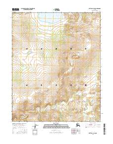
2016 Map of Bettles A-3 SW
USGS Topo · Published 2016About this map
Sithylemenkat Lake dominates the northern high country of this interior Alaskan landscape, serving as a primary hydrologic landmark in the southern reaches of the Brooks Range foothills. The terrain is defined by the winding course of the Kanuti Kilolitna River, which cuts through the southern portion of the quadrangle. This 2016 survey highlights a vast, unpopulated wilderness within the t15n r18w and t14n r19w townships, where the natural drainage patterns and elevation contours are the only markers of place. The lack of roads or permanent structures reflects the preserved character of the Yukon-Koyukuk region, where local geography is dictated entirely by water systems and the rising slopes surrounding the central lake basin.
Find a feature on this map
6 named features on this map. Tap any name to fly to it.
Don’t see what you’re looking for? This feature index may not catch every label — zoom into the map to look around manually.
Map Details
Editions of this 2016 Bettles A-3 SW Map
This is the sole edition of this map. No revisions or reprints were ever made.
Other maps of this area

1951 · Bettles
USGS Topo · 1:250,000

1951 · Tanana
USGS Topo · 1:250,000

1956 · Bettles
USGS Topo · 1:250,000

1956 · Tanana D-4
USGS Topo · 1:63,360

1956 · Tanana D-3
USGS Topo · 1:63,360

1956 · Tanana
USGS Topo · 1:250,000

1960 · Tanana
USGS Topo · 1:250,000
1970 · Bettles A-3
USGS Topo · 1:63,360
1970 · Bettles A-4
USGS Topo · 1:63,360
2016 · Bettles A-3 SE
USGS Topo · 1:25,000