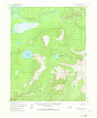
1970 Map of Bettles A-3
USGS Topo · Published 1973About this map
Sithylemenkat Lake and Tokusatatquaten Lake dominate the central basin of this interior Alaskan landscape, which was mapped via photogrammetric methods in 1970. The drainage pattern is defined by the winding course of the Kanuti River to the north and its tributary, the Kanuti Kilolitna River, which cuts through the southern reaches of the quadrangle. This survey represents a remote wilderness area before the establishment of major modern infrastructure, showing unsurveyed land lines as predetermined by the Bureau of Land Management. The map illustrates the complex relationship between the low-lying swampy basins and the rising elevations that surround these significant water bodies, providing a primary record of the topography and hydrology as it existed in the early 1970s.
Find a feature on this map
4 named features on this map. Tap any name to fly to it.
Don’t see what you’re looking for? This feature index may not catch every label — zoom into the map to look around manually.
Map Details
Editions of this 1970 Bettles A-3 Map
This is the sole edition of this map. No revisions or reprints were ever made.
Other maps of this area

1951 · Bettles
USGS Topo · 1:250,000

1951 · Tanana
USGS Topo · 1:250,000

1956 · Bettles
USGS Topo · 1:250,000

1956 · Tanana D-2
USGS Topo · 1:63,360

1956 · Tanana D-4
USGS Topo · 1:63,360

1956 · Tanana D-3
USGS Topo · 1:63,360

1956 · Tanana
USGS Topo · 1:250,000

1960 · Tanana
USGS Topo · 1:250,000
1970 · Bettles B-4
USGS Topo · 1:63,360
1970 · Bettles A-4
USGS Topo · 1:63,360