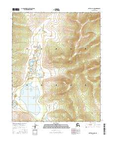
2016 Map of Bettles A-6 NW
USGS Topo · Published 2016About this map
Lake Todatonten dominates the southwestern quadrant of this 2016 survey, serving as a primary hydrologic landmark in the interior Alaskan wilderness. This expansive water body feeds into the Mentanontli River, which flows westward along the southern edge of the sheet. The terrain transitions from the low-lying wetland environment around the lake to a series of significant ridges and valleys in the east, characterized by steep contour gradients that define the local drainage patterns. The map is organized by the Public Land Survey System grids for t16n r26w, t16n r25w, t15n r26w, and t15n r25w, showing the systematic division of this remote territory.
Find a feature on this map
6 named features on this map. Tap any name to fly to it.
Don’t see what you’re looking for? This feature index may not catch every label — zoom into the map to look around manually.
Map Details
Editions of this 2016 Bettles A-6 NW Map
This is the sole edition of this map. No revisions or reprints were ever made.
Other maps of this area

1951 · Hughes
USGS Topo · 1:250,000

1951 · Bettles
USGS Topo · 1:250,000

1955 · Hughes A-1
USGS Topo · 1:63,360

1956 · Hughes
USGS Topo · 1:250,000

1956 · Bettles
USGS Topo · 1:250,000

1964 · Hughes
USGS Topo · 1:250,000

1965 · Hughes
USGS Topo · 1:250,000
1970 · Bettles A-6
USGS Topo · 1:63,360
1970 · Bettles B-6
USGS Topo · 1:63,360
1986 · Hughes B-1
USGS Topo · 1:63,360