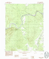
1986 Map of Hughes B-1
USGS Topo · Published 1986About this map
The Koyukuk River winds through this interior Alaskan landscape, defining the topography between the Klaluthyiit Bluff and the prominent heights of Kohokachalla Mountain. This mid-1980s provisional study, based on 1970s aerial photography, documents a remote riverine environment where human presence is marked only by a solitary Cabin along the main channel and a Tractor Trail cutting through the terrain. The hydrological network is dense, featuring the confluence of the Mentanontli River and several drainages such as Discovery Creek and Slathlouka Creek. The map provides specific detail for river navigation and bush travel, identifying features like Curve Slough and Dog Island, alongside large water bodies like Lake Nogrilenten. This is a landscape where natural drainage and elevation dictate movement, offering researchers a clear look at the wilderness before modern shifts in the river's course.
Find a feature on this map
13 named features on this map. Tap any name to fly to it.
Don’t see what you’re looking for? This feature index may not catch every label — zoom into the map to look around manually.
Map Details
Editions of this 1986 Hughes B-1 Map
This is the sole edition of this map. No revisions or reprints were ever made.
Other maps of this area

1951 · Hughes
USGS Topo · 1:250,000

1951 · Bettles
USGS Topo · 1:250,000

1955 · Hughes A-2
USGS Topo · 1:63,360

1955 · Hughes A-1
USGS Topo · 1:63,360

1956 · Hughes
USGS Topo · 1:250,000

1956 · Bettles
USGS Topo · 1:250,000
1956 · Hughes A-2
USGS Topo · 1:63,360

1964 · Hughes
USGS Topo · 1:250,000

1965 · Hughes
USGS Topo · 1:250,000
1970 · Bettles A-6
USGS Topo · 1:63,360