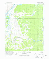
1970 Map of Bettles B-6
USGS Topo · Published 1977About this map
The Koyukuk River and Kanuti River dominate this 1970 landscape, illustrating a remote Alaskan interior defined by its winding waterways and seasonal overland routes. The topography highlights the distinct Kanuti Canyon, where the river carves through the terrain, while the southern reaches feature a pingo, a characteristic permafrost-induced landform. Evidence of human passage is marked primarily by an extensive network of sled and foot routes, including the Allakaket Tanana Winter Trail, Allakaket Trail, and Tanana Trail. These pathways suggest the critical importance of winter travel in an era when permanent infrastructure was limited to occasional structures like the isolated Cabin found near the riverbanks. The map captures the region before more modern developments, preserving the layout of traditional trails and the undisturbed course of the Mentanontli River.
Find a feature on this map
14 named features on this map. Tap any name to fly to it.
Don’t see what you’re looking for? This feature index may not catch every label — zoom into the map to look around manually.
Map Details
Editions of this 1970 Bettles B-6 Map
2 editions found
Other maps of this area

1951 · Hughes
USGS Topo · 1:250,000

1951 · Bettles
USGS Topo · 1:250,000

1955 · Hughes A-1
USGS Topo · 1:63,360

1956 · Hughes
USGS Topo · 1:250,000

1956 · Bettles
USGS Topo · 1:250,000

1964 · Hughes
USGS Topo · 1:250,000

1965 · Hughes
USGS Topo · 1:250,000
1970 · Bettles A-6
USGS Topo · 1:63,360
1970 · Bettles B-5
USGS Topo · 1:63,360
1970 · Bettles B-6
USGS Topo · 1:63,360