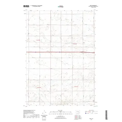
2017 Map of Betts
USGS Topo · Published 2017About this map
Betts serves as the focal point for this Davison County survey, situated at the junction of the interstate and the rural section line roads that define the local township grids. The landscape is characterized by its agricultural geometry, where north-south routes like 403rd Ave and 404th Ave intersect with an orderly series of east-west streets, ranging from 251st St in the north to 259th St in the south. The natural drainage of the prairie is evident in the meandering paths of Dry Run and Enemy Cr, which cut across the otherwise structured farm plots. Local history and genealogy researchers will find important landmarks at the edges of the township, including Mount Vernon Cem and Lisbon Township Cem, both of which are documented alongside the well-traveled Cemetery Rd.
Find a feature on this map
26 named features on this map. Tap any name to fly to it.
Don’t see what you’re looking for? This feature index may not catch every label — zoom into the map to look around manually.
Map Details
Editions of this 2017 Betts Map
This is the sole edition of this map. No revisions or reprints were ever made.
Other maps of this area

1899 · Mitchell
USGS Topo · 1:125,000

1955 · Mitchell
USGS Topo · 1:250,000

1957 · Loomis
USGS Topo · 1:24,000

1957 · Mitchell
USGS Topo · 1:24,000

1959 · Mitchell
USGS Topo · 1:250,000
1979 · Letcher SW
USGS Topo · 1:24,000

1979 · Storla
USGS Topo · 1:24,000

1980 · Old Stickney Lake
USGS Topo · 1:24,000
1980 · Mitchell SW
USGS Topo · 1:24,000
1980 · Shoemaker Dam
USGS Topo · 1:24,000