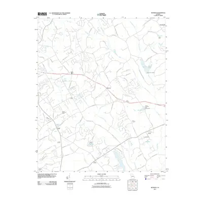
2011 Map of Between
USGS Topo · Published 2011About this map
The Alcovy River and its winding tributaries, including Beaverdam Creek and Big Flat Creek, define the rolling landscape of Walton County in this 2011 survey. The uniquely named settlement of Between serves as a central point, situated along a network of country roads like Nunnally Farm Rd and New Hope Church Rd. This edition reflects a late 20th-century transition, showing the expansion of residential roads and small private airfields like Spring Valley Farm Airport alongside traditional rural landmarks. Genealogists will find a high density of family and community burial sites, from Tucker Cemetery in the center to the Dickinson Cemetery and Mitchell Cemetery on the periphery. Small-scale water management is evident in the numerous localized impoundments such as Williamson Lake, Lake Monroe, and Stuarts Lake, illustrating how the region's hydrology was adapted for local utility and recreation.
Find a feature on this map
96 named features on this map. Tap any name to fly to it.
Don’t see what you’re looking for? This feature index may not catch every label — zoom into the map to look around manually.
Map Details
Editions of this 2011 Between Map
This is the sole edition of this map. No revisions or reprints were ever made.
Other maps of this area

1896 · Monroe
USGS Topo · 1:125,000

1953 · Athens
USGS Topo · 1:250,000

1958 · Athens
USGS Topo · 1:250,000

1959 · Athens
USGS Topo · 1:250,000

1963 · Athens
USGS Topo · 1:250,000

1964 · Bold Springs
USGS Topo · 1:24,000
1964 · Loganville
USGS Topo · 1:24,000

1964 · Between
USGS Topo · 1:24,000

1964 · Monroe
USGS Topo · 1:24,000

1964 · Winder South
USGS Topo · 1:24,000