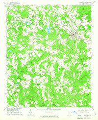
1964 Map of Loganville
USGS Topo · Published 1965About this map
The town of Loganville serves as the focal point of this mid-1960s survey, situated where the borders of Gwinnett and Walton counties meet. The landscape is defined by the branching tributaries of Big Haynes Creek and Little Haynes Creek, which together create a complex network of ridges and valleys. A snapshot of local community life is preserved through numerous rural landmarks, including the High Sch and several prominent churches like Haynes Creek Ch and Center Hill Ch.
Find a feature on this map
61 named features on this map. Tap any name to fly to it.
Don’t see what you’re looking for? This feature index may not catch every label — zoom into the map to look around manually.
Map Details
Editions of this 1964 Loganville Map
2 editions found
Other maps of this area

1888 · Atlanta
USGS Topo · 1:125,000

1890 · Atlanta
USGS Topo · 1:125,000

1892 · Atlanta
USGS Topo · 1:125,000

1895 · Atlanta
USGS Topo · 1:125,000

1896 · Monroe
USGS Topo · 1:125,000

1953 · Atlanta
USGS Topo · 1:250,000

1953 · Athens
USGS Topo · 1:250,000

1956 · Snellville
USGS Topo · 1:24,000

1956 · Conyers
USGS Topo · 1:24,000

1957 · Atlanta
USGS Topo · 1:250,000