
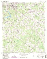
1964 Map of Winder South
USGS Topo · Published 1965About this map
Winder and its southern neighboring communities define this mid-1960s landscape, where the Seaboard Air Line railroad and a dense network of country roads connect small settlements. To the west, Fort Yargo State Park centers on the waters of Marburg, while the historical Old Fort and a Covered Bridge on the Apalachee River hint at the area's older landmarks. The map records several family-named burial grounds and rural congregations, including Bethlehem Ch and Smith Chapel Cem, alongside educational centers like Glenwood High Sch.
Find a feature on this map
87 named features on this map. Tap any name to fly to it.
Don’t see what you’re looking for? This feature index may not catch every label — zoom into the map to look around manually.
Map Details
Editions of this 1964 Winder South Map
3 editions found

Other maps of this area

1891 · Gainesville
USGS Topo · 1:125,000

1896 · Monroe
USGS Topo · 1:125,000

1953 · Athens
USGS Topo · 1:250,000

1954 · Greenville
USGS Topo · 1:250,000

1958 · Greenville
USGS Topo · 1:250,000

1958 · Athens
USGS Topo · 1:250,000

1959 · Athens
USGS Topo · 1:250,000

1963 · Athens
USGS Topo · 1:250,000

1964 · Bold Springs
USGS Topo · 1:24,000

1964 · Between
USGS Topo · 1:24,000