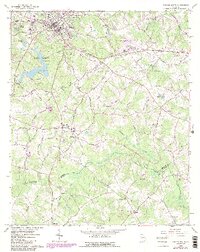
1964 Map of Winder South
USGS Topo · Published 1986About this map
Winder and its southern surroundings are defined by the convergence of the Seaboard Railroad and several historic transportation corridors, including the noted Old Railroad Grade and Argonne Road. The landscape features the expansive waters of Masseys Lake and Marbury Creek within Fort Yargo State Park, providing a distinct geographic anchor west of the city. To the south, the terrain becomes a patchwork of small communities like Bethlehem and Gratis, where family legacy is preserved through numerous rural landmarks such as Smith Chapel Cem and Hebron Ch. This mid-century survey also documents the industrial and civic infrastructure of the era, from the Winder Airport and Radio Tower (WIMO) to the Glenwood High Sch. The map records the county lines where Barrow, Walton, and Oconee counties meet along the Apalachee River.
Find a feature on this map
56 named features on this map. Tap any name to fly to it.
Don’t see what you’re looking for? This feature index may not catch every label — zoom into the map to look around manually.
Map Details
Editions of this 1964 Winder South Map
3 editions found


Other maps of this area

1891 · Gainesville
USGS Topo · 1:125,000

1896 · Monroe
USGS Topo · 1:125,000

1953 · Athens
USGS Topo · 1:250,000

1954 · Greenville
USGS Topo · 1:250,000

1958 · Greenville
USGS Topo · 1:250,000

1958 · Athens
USGS Topo · 1:250,000

1959 · Athens
USGS Topo · 1:250,000

1963 · Athens
USGS Topo · 1:250,000

1964 · Bold Springs
USGS Topo · 1:24,000

1964 · Between
USGS Topo · 1:24,000