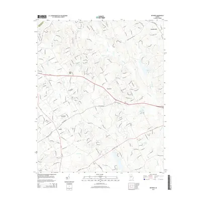
2014 Map of Between
USGS Topo · Published 2014About this map
The Alcovy River and its numerous tributaries, including Little Flat Cr and Wolf Cr, define the drainage patterns of this Walton County landscape. Small, traditionally-named communities like Between, Split Silk, Youth, and Nicholasville are linked by a network of historic routes including the Atlanta Hwy and Us-78. This 2014 survey reveals a high density of family and community burial grounds, such as Old Zion Cemetery, Corinth Cem, and Mitchell Cem, which are vital for genealogical research in this part of Georgia. The presence of the Spring Valley Farm Airport near the center of the sheet highlights the mix of rural aviation and agricultural land use. Water features are a prominent characteristic of the area, with several private or named impoundments like Lake Monroe, Stuarts Lake, and Black Lake dotting the creek valleys.
Find a feature on this map
40 named features on this map. Tap any name to fly to it.
Don’t see what you’re looking for? This feature index may not catch every label — zoom into the map to look around manually.
Map Details
Editions of this 2014 Between Map
This is the sole edition of this map. No revisions or reprints were ever made.
Other maps of this area

1896 · Monroe
USGS Topo · 1:125,000

1953 · Athens
USGS Topo · 1:250,000

1958 · Athens
USGS Topo · 1:250,000

1959 · Athens
USGS Topo · 1:250,000

1963 · Athens
USGS Topo · 1:250,000

1964 · Bold Springs
USGS Topo · 1:24,000
1964 · Loganville
USGS Topo · 1:24,000

1964 · Between
USGS Topo · 1:24,000

1964 · Monroe
USGS Topo · 1:24,000

1964 · Winder South
USGS Topo · 1:24,000