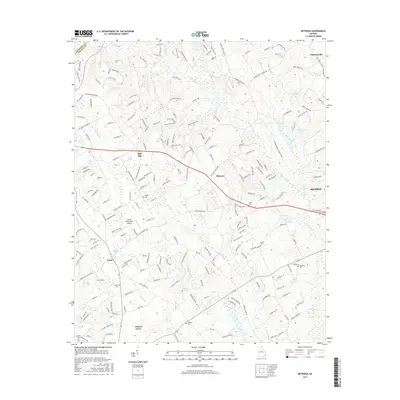
2017 Map of Between
USGS Topo · Published 2017About this map
Between sits at a crossroads in Walton County, surrounded by smaller namesake settlements such as Split Silk, Youth, and Walnut Grove. The landscape is defined by the headwaters of the Alcovy River and numerous drainage systems like Little Flat Cr and Cornish Cr, which feed into local reservoirs including Lake Monroe and Stuarts Lake. This modern digital survey shows the area's transition into a more developed suburban corridor, though it retains deep roots evidenced by family and community landmarks like Tucker Cem, Brooks Cem, and Mitchell Cem. The Spring Valley Farm Airport serves as a distinct aviation landmark in a region characterized by ridge-top developments like Maple Creek Ridge and Seths Ridge, which overlook the winding creek beds that have shaped local property lines for generations.
Find a feature on this map
205 named features on this map. Tap any name to fly to it.
Don’t see what you’re looking for? This feature index may not catch every label — zoom into the map to look around manually.
Map Details
Editions of this 2017 Between Map
This is the sole edition of this map. No revisions or reprints were ever made.
Other maps of this area

1896 · Monroe
USGS Topo · 1:125,000

1953 · Athens
USGS Topo · 1:250,000

1958 · Athens
USGS Topo · 1:250,000

1959 · Athens
USGS Topo · 1:250,000

1963 · Athens
USGS Topo · 1:250,000

1964 · Bold Springs
USGS Topo · 1:24,000
1964 · Loganville
USGS Topo · 1:24,000

1964 · Between
USGS Topo · 1:24,000

1964 · Monroe
USGS Topo · 1:24,000

1964 · Winder South
USGS Topo · 1:24,000