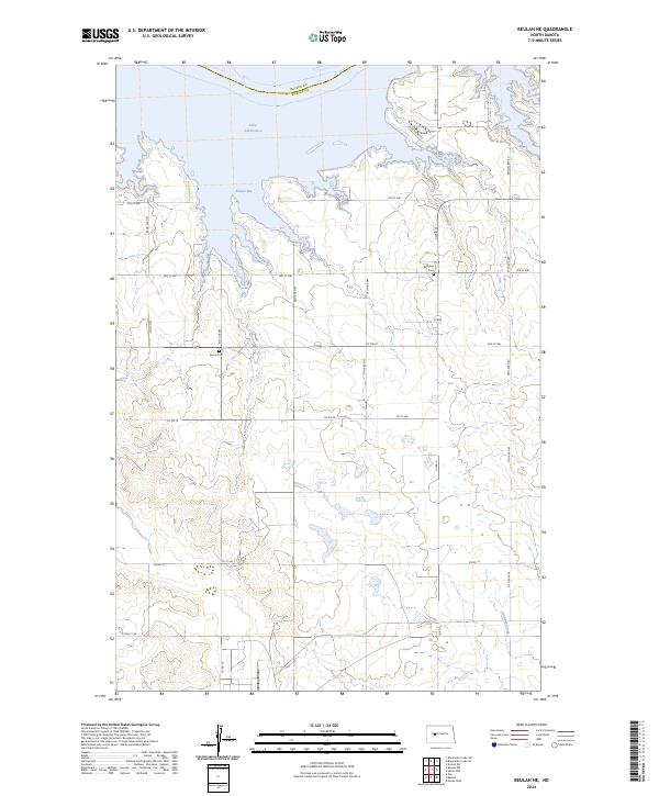
2024 Map of Beulah NE
USGS Topo · Published 2024About this map
Lake Sakakawea dominates the northern reaches of this Mercer County landscape, where the waters of Renner Bay and the shoreline near Lake Shore Est meet the rolling prairie. The map documents a rural transition where traditional Section 16 school lands and agricultural grids are bisected by modern infrastructure. For those researching family history in the region, the placement of Kronthal Cem and Peace Cem provides essential coordinate data for local ancestral sites. The terrain is defined by the drainage of Antelope Creek to the southeast and a network of county roads, such as Co RD 21 and Co RD 28, that trace the legacy of the Public Land Survey System through Townships 145 and 146 North.
Find a feature on this map
29 named features on this map. Tap any name to fly to it.
Don’t see what you’re looking for? This feature index may not catch every label — zoom into the map to look around manually.
Map Details
Editions of this 2024 Beulah NE Map
This is the sole edition of this map. No revisions or reprints were ever made.
Other maps of this area

1954 · McClusky
USGS Topo · 1:250,000

1958 · McClusky
USGS Topo · 1:250,000

1967 · Blackwater Lake SE
USGS Topo · 1:24,000

1967 · Blackwater Lake SW
USGS Topo · 1:24,000

1967 · Emmet SW
USGS Topo · 1:24,000

1968 · Beulah
USGS Topo · 1:24,000

1968 · Hazen West
USGS Topo · 1:24,000

1969 · Beulah NE
USGS Topo · 1:24,000
1969 · Hazen NW
USGS Topo · 1:24,000
1969 · Beulah NW
USGS Topo · 1:24,000