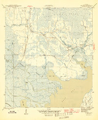
1945 Map of Beverly
USGS Topo · Published 1945About this map
Tates Hell Swamp dominates this coastal landscape, a dense network of blackwater creeks and wetlands that shaped the early logging and maritime economy of the Florida Panhandle. The map reveals the intricate drainage of Deep Creek and Graham Creek as they flow toward the Apalachicola River and East River. Small settlements and family names are preserved here, including the communities of Beverly and Creels, and historic sites like Hays Place. The transportation of the era is evident in the presence of the Old Logging RR, which speaks to the industrial extraction of timber from the wetlands. Along the water, specialized points such as Gardner Landing and Butcher Pen Landing indicate centers of local trade and movement. The southern reaches of the map open into East Bay, flanked by features like Tank Island and Round Bay, where the St Marks River meets the Gulf tidal system.
Find a feature on this map
35 named features on this map. Tap any name to fly to it.
Don’t see what you’re looking for? This feature index may not catch every label — zoom into the map to look around manually.
Map Details
Editions of this 1945 Beverly Map
4 editions found
Other maps of this area

1943 · West Pass
USGS Topo · 1:31,680

1943 · Apalachicola
USGS Topo · 1:31,680

1943 · Jackson River
USGS Topo · 1:24,000

1944 · Green Point
USGS Topo · 1:31,680

1944 · Apalachicola
USGS Topo · 1:24,000

1944 · Forbes Island
USGS Topo · 1:24,000

1945 · Forbes Island
USGS Topo · 1:31,680

1945 · Tates Hell Swamp
USGS Topo · 1:31,680

1945 · Beverly
USGS Topo · 1:31,680

1945 · Jackson River
USGS Topo · 1:31,680