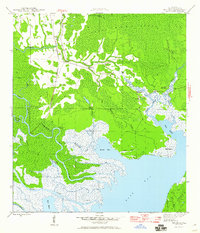
1945 Map of Beverly
USGS Topo · Published 1960About this map
Tates Hell Swamp dominates this coastal landscape in the mid-1940s, revealing a region defined by its labyrinthine waterways and the industrial footprint of timber harvesting. The Apalachicola Northern rail line cuts through the western portion, passing the small settlement of Beverly, while an Old Logging RR traces further north, indicating the historical reach of the local logging industry. The map captures the intricate drainage system where Deep Creek and Doyle Creek feed toward the East Bay, bordered by maritime landmarks like the East Bay Fire Tower and Bethlehem Ch. This survey is particularly useful for identifying family-named sites and vanished working camps, such as Hays Place and Creels Side Camp, which offer insight into the remote residential and commercial patterns of Franklin County before modern development altered the swamp's interior.
Find a feature on this map
37 named features on this map. Tap any name to fly to it.
Don’t see what you’re looking for? This feature index may not catch every label — zoom into the map to look around manually.
Map Details
Editions of this 1945 Beverly Map
4 editions found
Other maps of this area

1943 · West Pass
USGS Topo · 1:31,680

1943 · Apalachicola
USGS Topo · 1:31,680

1943 · Jackson River
USGS Topo · 1:24,000

1944 · Green Point
USGS Topo · 1:31,680

1944 · Apalachicola
USGS Topo · 1:24,000

1944 · Forbes Island
USGS Topo · 1:24,000

1945 · Forbes Island
USGS Topo · 1:31,680

1945 · Tates Hell Swamp
USGS Topo · 1:31,680

1945 · Beverly
USGS Topo · 1:31,680

1945 · Jackson River
USGS Topo · 1:31,680