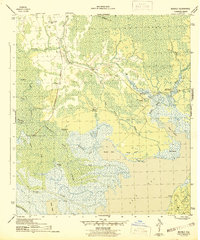
1945 Map of Beverly
USGS Topo · Published 1945About this map
The Apalachicola Northern railroad cuts through the heart of the Florida panhandle on this 1945 survey, connecting the small settlement of Beverly with the river-fed wetlands of Franklin County. This landscape is defined by the convergence of the St Marks River and East River as they flow toward East Bay. Human activity is primarily centered around the timber and river trade, evidenced by the Old Logging RR and established camps such as Creels Side Camp.
Find a feature on this map
35 named features on this map. Tap any name to fly to it.
Don’t see what you’re looking for? This feature index may not catch every label — zoom into the map to look around manually.
Map Details
Editions of this 1945 Beverly Map
4 editions found
Other maps of this area

1943 · West Pass
USGS Topo · 1:31,680

1943 · Apalachicola
USGS Topo · 1:31,680

1943 · Jackson River
USGS Topo · 1:24,000

1944 · Green Point
USGS Topo · 1:31,680

1944 · Apalachicola
USGS Topo · 1:24,000

1944 · Forbes Island
USGS Topo · 1:24,000

1945 · Forbes Island
USGS Topo · 1:31,680

1945 · Tates Hell Swamp
USGS Topo · 1:31,680

1945 · Beverly
USGS Topo · 1:31,680

1945 · Jackson River
USGS Topo · 1:31,680