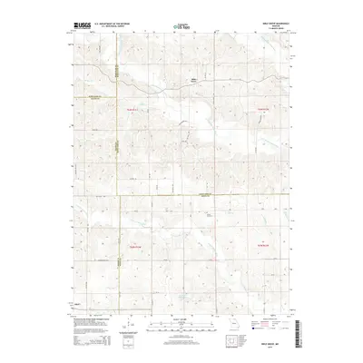
2015 Map of Bible Grove
USGS Topo · Published 2015About this map
Bible Grove sits at the heart of this Northeast Missouri landscape, where the rural terrain is defined by the complex drainage of the S Fork Middle Fabius River and the N Fork S Fabius River. The map reveals a land divided by the converging boundaries of Scotland, Schuyler, Adair, and Knox counties. The settlement patterns follow a network of county roads and named ways such as Rattle Snake Rd and Old Trail Rd, which navigate the various ridges and creek valleys. Evidence of local family history is found at Slocum Cemetery and near Rowland-Kloppenstein Lake, while small waterways like Meadow Brook and Plum Br feed into the larger river systems. The small community of Adair appears in the southwestern corner, marking the transition between county lines in this agricultural region.
Find a feature on this map
57 named features on this map. Tap any name to fly to it.
Don’t see what you’re looking for? This feature index may not catch every label — zoom into the map to look around manually.
Map Details
Editions of this 2015 Bible Grove Map
This is the sole edition of this map. No revisions or reprints were ever made.
Other maps of this area

1903 · Edina
USGS Topo · 1:125,000

1954 · Centerville
USGS Topo · 1:250,000

1957 · Centerville
USGS Topo · 1:250,000

1958 · Centerville
USGS Topo · 1:250,000

1965 · Memphis
USGS Topo · 1:24,000
1965 · Edina
USGS Topo · 1:24,000

1965 · Greensburg
USGS Topo · 1:24,000

1965 · Downing NW
USGS Topo · 1:24,000

1966 · Brashear
USGS Topo · 1:24,000

1966 · Downing
USGS Topo · 1:24,000