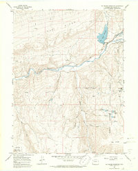
1966 Map of Big Beaver Reservoir
USGS Topo · Published 1970About this map
White River flows through the central canyon of this 1960s landscape, flanked by the massive elevations of Oak Ridge and Big Ridge. The terrain is dominated by the White River National Forest, where the presence of the Bel-aire Rearing Sta and water management features like Marcott Ditch suggest a focus on wildlife conservation and local irrigation. High-altitude hydrology is a defining characteristic here, with numerous alpine water bodies such as Burro Mtn Lake, Cabin Lake, and Shadow Lake dotting the southeastern ridges.
Find a feature on this map
35 named features on this map. Tap any name to fly to it.
Don’t see what you’re looking for? This feature index may not catch every label — zoom into the map to look around manually.
Map Details
Editions of this 1966 Big Beaver Reservoir Map
4 editions found
Other maps of this area

1906 · Grand Hogback
USGS Topo · 1:125,000

1910 · Danforth Hills
USGS Topo · 1:125,000

1910 · Grand Hogback
USGS Topo · 1:125,000

1912 · Meeker
USGS Topo · 1:62,500

1914 · Meeker
USGS Topo · 1:62,500

1954 · Craig
USGS Topo · 1:250,000

1957 · Craig
USGS Topo · 1:250,000

1957 · Leadville
USGS Topo · 1:250,000

1958 · Craig
USGS Topo · 1:250,000

1959 · Leadville
USGS Topo · 1:250,000