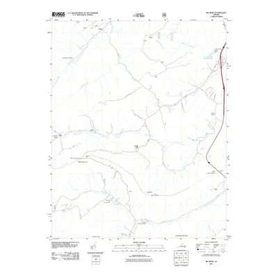
2011 Map of Big Bend
USGS Topo · Published 2011About this map
Walker Mountain and Little Walker Mountain dominate this southwest Virginia landscape, creating a series of narrow valleys where small settlements and rural infrastructure have taken root. Suiter and Effna sit along the creek beds, connected by a network of winding mountain roads like State Rte 620 and Stony Fork Rd. The engineering of the modern era is evident in the Big Walker Mountain Tunnel and the Walker Mountain Lookout, which provide vantage points and passage through the steep terrain.
Find a feature on this map
36 named features on this map. Tap any name to fly to it.
Don’t see what you’re looking for? This feature index may not catch every label — zoom into the map to look around manually.
Map Details
Editions of this 2011 Big Bend Map
This is the sole edition of this map. No revisions or reprints were ever made.
Other maps of this area

1887 · Pocahontas
USGS Topo · 1:125,000

1889 · Wytheville
USGS Topo · 1:125,000

1891 · Pocahontas
USGS Topo · 1:125,000

1892 · Wytheville
USGS Topo · 1:125,000

1894 · Pocahontas
USGS Topo · 1:125,000

1895 · Pocahontas
USGS Topo · 1:125,000

1930 · Speedwell
USGS Topo · 1:62,500
1935 · Nye Cove
USGS Topo · 1:24,000
1935 · Garden Mountain
USGS Topo · 1:24,000
1935 · Groseclose
USGS Topo · 1:24,000