
1973 Map of Big Bend Dam 4 NE
USGS Topo · Published 1976About this map
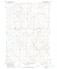
Crow Creek winds through a vast expanse of the South Dakota prairie in this 1973 photogrammetric survey, following a winding course that cuts through the townships of Mondamin, Pleasant Valley, and Eden. This landscape reflects the rural character of the region during the early 1970s, where the scattered human footprint is primarily marked by a grid of section lines and the isolated presence of the Duncan Ch. The map provides a detailed view of the border between Hand and Buffalo counties, capturing a moment when the prairie remained largely dedicated to agriculture and open grazing. For researchers, the presence of the church and the naming of specific topographic valleys like Pleasant Valley offer clear points of reference for tracing local historical sites and community hubs in a sparsely populated territory.
Find a feature on this map
6 named features on this map. Tap any name to fly to it.
Don’t see what you’re looking for? This feature index may not catch every label — zoom into the map to look around manually.
Map Details
Editions of this 1973 Big Bend Dam 4 NE Map
2 editions found
Other maps of this area

1949 · Vayland SW
USGS Topo · 1:24,000

1951 · Vayland SW
USGS Topo · 1:24,000

1953 · Huron
USGS Topo · 1:250,000

1954 · Huron
USGS Topo · 1:250,000

1973 · Big Bend Dam 4 SE
USGS Topo · 1:24,000

1973 · Ames
USGS Topo · 1:24,000

1973 · Gannvalley
USGS Topo · 1:24,000

1973 · Miller Dale Colony SW
USGS Topo · 1:24,000

1973 · Big Bend Dam 4 NW
USGS Topo · 1:24,000
1973 · Big Bend Dam 4 SW
USGS Topo · 1:24,000