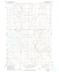
1973 Map of Duncan Church
USGS Topo · Published 1994About this map
Crow Creek winds through a landscape of named townships and rolling terrain along the boundary of Hand and Buffalo counties. The region is defined by distinct topographical areas such as Mondamin, Pleasant Valley, and Eden, showing a rural prairie environment centered on small community landmarks. A central point of interest is the Duncan Ch, which serves as a focal point for the surrounding homesteads and section lines. A solitary Grave label near the creek indicates a site of potential interest for genealogists and local historians, reflecting the sparse but significant human presence in this part of South Dakota during the early 1970s. The map also meticulously documents fence and field lines, offering a precise look at land division and agricultural use during this era.
Find a feature on this map
7 named features on this map. Tap any name to fly to it.
Don’t see what you’re looking for? This feature index may not catch every label — zoom into the map to look around manually.
Map Details
Editions of this 1973 Duncan Church Map
2 editions found
Other maps of this area

1949 · Vayland SW
USGS Topo · 1:24,000

1951 · Vayland SW
USGS Topo · 1:24,000

1953 · Huron
USGS Topo · 1:250,000

1954 · Huron
USGS Topo · 1:250,000

1973 · Big Bend Dam 4 SE
USGS Topo · 1:24,000

1973 · Ames
USGS Topo · 1:24,000

1973 · Gannvalley
USGS Topo · 1:24,000

1973 · Miller Dale Colony SW
USGS Topo · 1:24,000

1973 · Big Bend Dam 4 NW
USGS Topo · 1:24,000

1973 · Big Bend Dam 4 NE
USGS Topo · 1:24,000