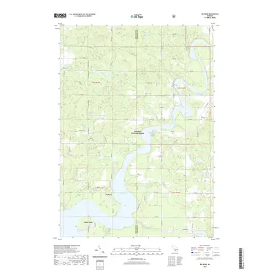
2019 Map of Big Bend
USGS Topo · Published 2019About this map
The Muskegon River and the extensive waters of Hardy Dam Pond dominate this portion of the Manistee National Forest, where the border between Newaygo and Mecosta counties meets. This 2019 survey shows the transition from the forested highlands to the river valley, centered on the settlement of Big Bend. The landscape is dotted with numerous glacial lakes, including Pearson Lake, Round Lake, and Brady Lake, alongside small watercourses like Fivemile Cr and Little Bear Cr. Local heritage is anchored by several established burial grounds, such as Goodwell Cem and Saint Peters Cem, which serve as vital markers for genealogical research in this rural Michigan township. Recreation and conservation are evident through Oxbow Park and the network of forest roads that crisscross the terrain.
Find a feature on this map
67 named features on this map. Tap any name to fly to it.
Don’t see what you’re looking for? This feature index may not catch every label — zoom into the map to look around manually.
Map Details
Editions of this 2019 Big Bend Map
This is the sole edition of this map. No revisions or reprints were ever made.
Other maps of this area

1954 · Midland
USGS Topo · 1:250,000

1958 · Midland
USGS Topo · 1:250,000

1958 · Sand Lake
USGS Topo · 1:62,500

1958 · Woodville
USGS Topo · 1:62,500

1958 · Big Rapids
USGS Topo · 1:62,500

1959 · Midland
USGS Topo · 1:250,000

1959 · Howard City
USGS Topo · 1:62,500

1966 · Midland
USGS Topo · 1:250,000

1976 · Big Rapids SW
USGS Topo · 1:24,000
1976 · Howard City NW
USGS Topo · 1:24,000